Fieldwork & Survey Service
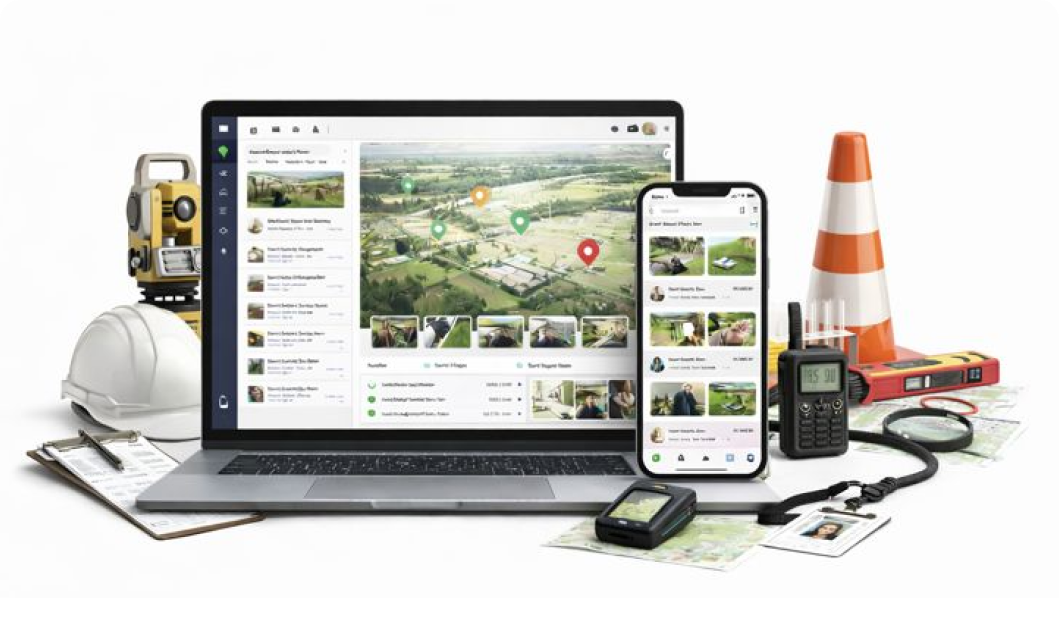
Assign survey locations, capture geo tagged data, and manage field activities using a structured CRM for Surveyors and survey management tool with offline GPS support and clear visit records.

Assign survey locations, capture geo tagged data, and manage field activities using a structured CRM for Surveyors and survey management tool with offline GPS support and clear visit records.
Save villages, plots, households, research points, water bodies, forest zones, or urban blocks using gps based survey management CRM with notes and images.
Assign interviews, inspections, measurements, audits, or observations using Survey route planning CRM.
Each visit includes GPS logs and time stamps to confirm survey completion, without live tracking.
Capture images, readings, and observations using survey crm with location tracking for accuracy and validation.
Attach survey forms, questionnaires, documents, and observations under each location using Research management CRM.
View completed visits, pending surveys, and collected data in a clean timeline useful for CRM for research industry needs.
Location CRM helps teams record survey sites accurately while working on the ground. Visits and timestamps are saved automatically, keeping studies clean and reliable. Data stays synced, so reviews feel smooth with no guesswork.


Survey points, observation sites, and routes are stored clearly for repeat visits. Movement logs are captured quietly, helping teams stay consistent. Fieldwork feels easier day to day, even in remote areas.


Assigned locations guide staff straight to the right sites without mix-ups. Visit proof and time records are kept automatically for audits. Reporting stays tidy, cutting follow-ups and delays.


Community sites and project locations stay organized and easy to revisit. Updates sync in real time, keeping teams aligned on the go. Work flows better, with less calling around.


Plots and sample points are saved with exact positions for each visit. Logs help track progress across seasons without confusion. Planning feels steadier, plain and simple.


Survey locations and checkpoints remain mapped clearly for large projects. Teams update tasks from the field, keeping coordination tight. Reviews become faster, with fewer loose ends.


Boundaries and survey points are recorded once and reused anytime. Movement and visit data are captured automatically, saving effort. Field days run smoother, with less backtracking.


Add survey locations and research sites
Assign survey tasks and visit schedules
Capture geo tagged notes, photos, and forms
Yes. You can save unlimited villages, plots, households, or research points with pins, notes, and photos. This supports large-scale research location CRM workflows and helps surveyors revisit exact sites without confusion during follow-up visits or long-term studies.
Yes. Researchers can add notes, upload photos, fill forms, and record observations directly from the field. All data is linked to the correct location, making survey management tool usage simple and avoiding data loss from manual transfers or scattered files.
Yes. The system supports offline GPS logging, allowing survey teams to capture locations, notes, and photos without network access. Once online, everything syncs automatically, making it reliable for rural, forest, or remote research zones using CRM for Surveyors.
Yes. Teams can upload geo tagged images, measurements, and observations tied to exact coordinates. This helps validate survey work and supports gps based survey management CRM requirements for audits, reviews, and research accuracy.
Yes. The timeline stores all visits with time stamps, notes, photos, and documents. You can review earlier surveys to analyze trends, plan follow-ups, or prepare reports. This helps maintain structured CRM for research industry records.